Key Terms
Coordinates - A set of numbers used in specifying the location of a point on a line, on a surface, or in space.
Extent - A view of map. An extent includes not only the geography centered on the screen, but also the level of magnification (zoom).
Layer - A set of data applied to a map. Layers can be turned on or off and multiple layers can be applied to a map at once.
The Layout
At startup, the initial extent appears along with the controls. There are six main sections (shown below).
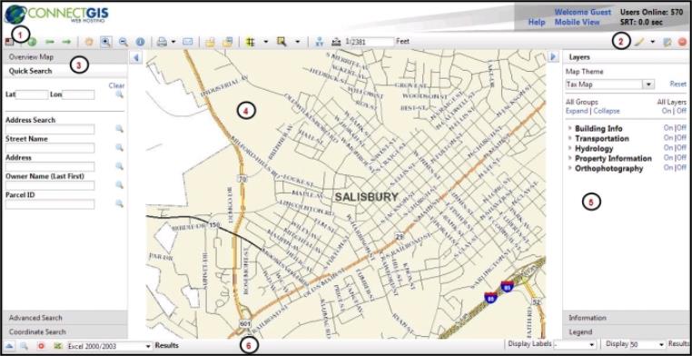
 Toolbar
 Mark Up Tools
 Search Panel
 Map
Map
 Layer/Info Panel
 Results Panel
The Toolbar
The following tools are available on the toolbar:
| Icon | Name | Description |

|
Toggle Overview Map | Reveal the Overview Map in the left panel. |

|
Initial Extent | Returns the map view to its default extent. |

|
Previous Extent | Move backwards through your extent history. |

|
Next Extent |
Move forward through your extent history. |

|
Pan | Move around the map without zooming in or out. |

|
Zoom In | Click and drag to create a box around the area you want to zoom in to. |

|
Zoom Out | Click and drag to create a box around the area you want to zoom out to. |

|
Identify Base Data Tool | Click to query information from the database. |

|
Print Map | Open a new window to allow you to print your current map view, including annotations. Click the down arrow to select print size. |

|
Email Map | Send a screenshot of your current map view, including annotations, to any email address. |

|
Download Shapefiles | Create a zip file of the GIS data and download it to your computer. *Note: This tool only downloads the first 500 features for layers that are currently turned on. To retrieve your complete set of data, you will need to contact your county/city. |

|
Download Georeferenced Image |
Create a zip file of a screenshot and world file and download it to your computer. |

|
Buffer an Area of the Map | Select a feature on the map, such as a parcel, and then identify all the other features within a given distance of it. Displays a menu that lets you search by source layer, target layer, and distance. |

|
Select tool | Select a single point or uses a lasso to select many points within a designated area. |

|
Get Coordinates on the Map | Displays latitude and longitude and other coordinates when you click on a map location. |

|
Measure an Area of the Map | Measures the length of line segments and area of polygons drawn on the map. |
Mark Up Tools
| Icon | Name | Description |

|
Add Graphics | Draw line segments on the map. |

|
Graphics Options | Change the graphic type, style, color, and size. |

|
Edit Graphics | Edit an existing graphic. |
|
|
Clear All Graphics |
Erase all added text and lines. |